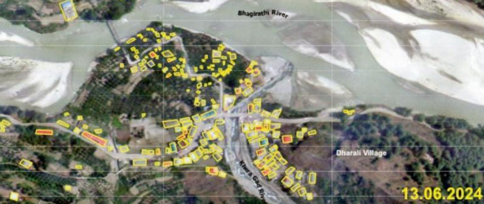

DEHRADUN: The scale of devastation in Dharali following the Aug 5 flash flood has been laid bare in the latest analysis of satellite images released by the Hyderabad-based National Remote Sensing Centre (NRSC), an arm of the Indian Space Research Organisation (ISRO).The comparative visuals provide the first concrete evidence of large-scale structural damage, showing over 130 buildings — big and small — directly hit by the disaster. Officials and disaster management experts said the imagery will be critical for assessing damage, planning rehabilitation, and identifying vulnerable areas for future mitigation.

Photo credit: NRSC
A pre-flood Cartosat-3 (Earth observation satellite) image from June 13, 2024, shows Dharali dotted with intact buildings, marked in yellow. In stark contrast, the post-event image from Aug 7 — just two days after the flash flood — outlines more than 130 structures in red, indicating direct impact from the raging Kheer Gad stream. According to NRSC’s analysis, the flood wiped out roads, plantations and entire habitations, leaving clear markers of destruction on the landscape.Residents, many of whom were evacuated, are still struggling to come to terms with the sudden loss of their homes and establishments. Sachindra Panwar, a local hotelier, said, “Looking at these images is like reliving the disaster all over again. Our homes, our fields, even the roads we walked every day — all of it has been wiped out.”

Photo credit: NRSC
A local shopkeeper, now living in a temporary shelter, added, “The images confirm what we saw with our own eyes — a substantial part of our town has vanished.”Earlier analysis of Cartosat-2S images released on Aug 7 showed that the flood damaged scores of buildings, altered river courses and left behind a debris field of nearly 20 hectares across Dharali and neighbouring Harsil. Much of the destruction was concentrated at the confluence of the Kheer Gad and Bhagirathi rivers, where floodwaters laden with debris and silt engulfed homes, shops, and roads, leaving a flattened grey sprawl where a thriving settlement once stood.The analysis also showed a fan-shaped debris spread measuring roughly 750 by 450 metres at the confluence. ISRO confirmed that several buildings were either swept away or buried under silt and rubble, while stream channels widened and the river morphology underwent significant changes — all hallmarks of a high-magnitude flash flood.